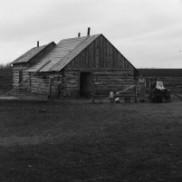
The Settlement Period
1880 - 1913
Documents the origins of the community through to the beginning of the first world war.
.jpg)
Maps
.JPG)
This essay describes the purpose and the initial development of the Pembina Manitou Archive.
PMA_2012_007320
.JPG)
This 1910 atlas features Manitoba as the postage stamp province and emphasizes the rail lines which served the province at that time.
PMA_2023_072164
A geographical history of the Mennonite West Reserve.
PMA_2024_072339
An analysis of the settlement patterns in the districts associated with the East Mennonite Reserve in Southern Manitoba.
PMA_2018_045675
An atlas of the many Mennonite communities of the West Reserve in Southern Manitoba.
PMA_2023_071848
.jpg)
This is a listing of all Manitoba newspaper which we currently are aware are available online. We will pdate the listing as we become aware of changes.
PMA_2013_014135
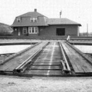
A map from the collection of the Miami Railway Station Museum.
PMA_2020_047044
A map of the CPR rail lines across Western Canada.
PMA_2020_047046
A document concerning the original sites of Darlingford and Darlington, featuring photographs, maps and news articles.
PMA_2021_050033
A map outlining the route of the Hind Expedition on its tour through Red River, Manitoba, and Assiniboia in 1858.
PMA_2022_063682