The Settlement Period
1880 - 1913
Documents the origins of the community through to the beginning of the first world war.
.jpg)
Maps
Published by the Manitoba Historical Society in 1970 and edited by John Warkentin and Richard Ruggles, the Historical Atlas of Manitoba contains maps of Manitoba dated 1612 to 1969.
PMA_2014_021767
Published by the Manitoba Historical Society in 1970 and edited by John Warkentin and Richard Ruggles, the Historical Atlas of Manitoba contains maps of Manitoba dated 1612 to 1969.
PMA_2014_021768
.JPG)
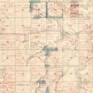
A listing by quarter section of the homesteaders of 2-9W in Southern Manitoba.
PMA_2018_045627
Subtitles "An Astonishing Cavalcade" : The 1874 Route of the North West Mounted Polica Across Manitoba..
PMA_2017_044419
This brochure promoted the amenities, the lands and services, available in 1889 to those wishing to homestead and settle in what was then the Rural Municipality of Louise - including what is now the western half of Pembina Municipality
PMA_2013_021157
Shows many early settlements and the boundaries of the municipalities ca 1900.
PMA_2013_018605
A scan of an 1878 map of Southern Manitoba indicating the townships surveyed to that year and indicating which sections had to that point been homesteaded
PMA_2022_064549
Published by the Dominion of Canada, this map also provides detailed railroad information.
PMA_2018_045677
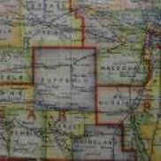
A collection of maps featuring the south west cornder of Manitoba.
PMA_2024_072418
The McKenzie Cemetery was deconstructed to clear the land for fieldwork, the stones bulldozed. Later some stones were reclaimed and set along the headland near the cemetery site.
PMA_2018_045629