Browse Historical Atlas of Manitoba
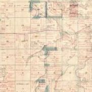
Table of Contents and Preface
by John Warkentin and Richard I. Ruggles
Page by page high definition files of the atlas, as well as chapter by chapter versions, are available in this collection.
PMA_2023_068512
Published by the Manitoba Historical Society in 1970 and edited by John Warkentin and Richard Ruggles, the Historical Atlas of Manitoba contains maps of Manitoba dated 1612 to 1969.
PMA_2014_021767
Published by the Manitoba Historical Society in 1970 and edited by John Warkentin and Richard Ruggles, the Historical Atlas of Manitoba contains maps of Manitoba dated 1612 to 1969.
PMA_2014_021768
Published by the Manitoba Historical Society in 1970 and edited by John Warkentin and Richard Ruggles, the Historical Atlas of Manitoba contains maps of Manitoba dated 1612 to 1969.
PMA_2014_021769
Published by the Manitoba Historical Society in 1970 and edited by John Warkentin and Richard Ruggles, the Historical Atlas of Manitoba contains maps of Manitoba dated 1612 to 1969.
PMA_2014_021770
Published by the Manitoba Historical Society in 1970 and edited by John Warkentin and Richard Ruggles, the Historical Atlas of Manitoba contains maps of Manitoba dated 1612 to 1969.
PMA_2014_021771
Published by the Manitoba Historical Society in 1970 and edited by John Warkentin and Richard Ruggles, the Historical Atlas of Manitoba contains maps of Manitoba dated 1612 to 1969.
PMA_2014_021772
Published by the Manitoba Historical Society in 1970 and edited by John Warkentin and Richard Ruggles, the Historical Atlas of Manitoba contains maps of Manitoba dated 1612 to 1969.
PMA_2014_021773
Published by the Manitoba Historical Society in 1970 and edited by John Warkentin and Richard Ruggles, the Historical Atlas of Manitoba contains maps of Manitoba dated 1612 to 1969.
PMA_2014_021774
Published by the Manitoba Historical Society in 1970 and edited by John Warkentin and Richard Ruggles, the Historical Atlas of Manitoba contains maps of Manitoba dated 1612 to 1969.
PMA_2014_021775